MPC
Research Projects (2007-08)
Identifying Number
MPC-293
Project Title
Development of GIS Multimodal Capacity Model for Northern Tier Freight Corridor
University
North Dakota State UniversityProject Investigators
Subhro Mitra and Denver Tolliver
Description of Project Abstract
With North Dakota being primarily an agricultural state, the freight carried by the transportation system is mainly agricultural products. Railroad plays a pivotal role in the transportation system of the state. The primary reason of this dominance is the long haul of agricultural products to ports and final destinations.
The railroad industry has changed since deregulation. The railroads have their own capacity constraints which may be detrimental in shipping agricultural products out of the state. Unavailability of railroad facilities in the future may force freight traffic to shift over to already congested highways.
To have a comprehensive view of the available infrastructure to transport products into and out of the state, it is not sufficient to study the highway and railroad network within the state; one must also conduct a thorough study of the whole corridor encompassing the destinations and origins of freight moving into and out of the state. Keeping this in mind, a corridor of six states—Wisconsin, Minnesota, North Dakota, Montana, Idaho and Washington—have been selected. This corridor is critical for the movement of goods within and beyond these northern tier states, and also for international freight movements to and from Canada.
In the past, there have been efforts at statewide freight modeling within these states. This existing knowledge base will serve as the starting point for this project. The project will contribute new knowledge by helping these states conduct research in a wider perspective that encompasses neighboring states. To make judicious use of investment funds for infrastructure development, there must be a comprehensive view of the transportation system in a multimodal perspective, and also a thorough analysis of the freight moving in and out of these states. This project will assess the existing infrastructure in terms of its capacity to handle existing freight traffic and its ability to sustain growth in the future.
Project Objective
This research aims to improve our understanding of freight transportation in the northern tier corridor in a multi-state and multimodal perspective. It will create a common knowledge of freight movement for the corridor comprising the six states. It will improve the knowledge of intermodal transportation systems and system capacity in the corridor. Some of the important research tasks are described below.
The first task will be to develop a GIS model of the existing highway and railroad networks in the corridor, along with intermodal facility locations. The next task will be to estimate the link capacities of the highways and railroads using the Highway Capacity Manual and parametric analysis methods, respectively. The estimated link and terminal capacities will serve as attributes for the GIS model and will function as building blocks for future analysis.
After identifying the present infrastructure facilities, the next task will be to identify the major freight generation and attraction locations in the region. This database will be derived from several sources including: the Bureau of Transportation Statistic's Freight Analysis Framework data base, the Railroad Waybill Sample, surveys of manufacturers and carriers, etc.
The next objective will be to assess the system capacity for the corridor as propounded by Morlok et al. (references [1] and [2]). The MAXCAP model [1] will be used to estimate the corridor system capacity.
maxZ
M =

x
rWhere:
- ZM = system capacity
- xr = loaded volume on traffic lane r
The traffic lane r represents an O-D pair in the proposed system. In the system, there are a set of constraints primarily on traffic patterns, arc vehicle and cargo flows, arc congestion delays, terminal capacities, fleet size, and levels of service. In the proposed research, the MAXCAP will be used to estimate system capacity. However, this study will go beyond previous ones by having the O-D pairs in multiple modes and also considering the interactions between trucks and railroads.
The next objective will be to measure the capacity flexibility of the transportation system to accommodate changing demands and traffic patterns. In this module the ADDVOL model [2] will be used to estimate the flexibility of the transportation system.
maxZ
A =
X
r +
 r
rWhere
- ZA = adjusted system capacity
- r = additional cargo on traffic lane r
The study area of the proposed corridor includes the highways and railroads through six states; namely Wisconsin, Minnesota, North Dakota, Montana, Idaho and Washington.
- Highways comprised of I-94, I-15, I-82, I-184, I-5, I-29, I-90, I-35, I-39 that connect the Northern tier corridor and other north/south US interstates in these states.
- Class I Railroad owned and operated by BNSF, CPRS, UP along with local and regional railroads.
- The Intermodal transfer locations within the five states mentioned.
- All freight attraction and generation zones within these states.
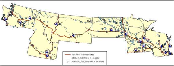
Map 1. Northern Tier State Corridor.
Contributions/Potential Applications of Research
(1) Identify bottleneck locations in the freight corridor. (2) Justify infrastructure investment for capacity expansion. (3) Identify intermodal locations for capacity enhancement. (4) Study truck and railroad interaction and consider project planning on collaborative approach between public and private entities. Although the study will focus on North Dakota and the northern tier, the concepts and methods developed in this project can be used to develop similar networks and models in other states of the region.
Technology Transfer Activities
The project will produce several tangible benefits for researchers and transportation practitioners, including: (1) a railroad and highway multimodal GIS Model, (2) a system capacity analysis procedure applicable to freight corridors, and (3) multimodal routing opportunities. The technology transfer benefits will be shared by transportation planners and policy makers in making judicious use of infrastructure investment funds. This project will also provide useful information to the shippers and carriers of these states.
Time Duration
July 1, 2007 – June 30, 2008
Yearly and Total Project Cost
$66,000
TRB Keywords
Freight, capacity, corridor, intermodal, multimodal, northern tier